Above
Inside of Ka’au Crater. Diamond Head and Waikiki can be seen in the distance.
There are three craters (or, “tuff cones” if you want to be nerdy about it) around Honolulu. The famous and iconic Diamond Head, the infamous Koko Head (notorious for the steep 1,048 step hike) and the lesser known Ka’au Crater. Unlike the first two, you can’t drive up to Ka’au Crater. You gotta hike through a valley just to see it. But, wow, what a hike.
Over the course of 5 hours, you’ll walk through the forest, cross streams, see three waterfalls (scrambling up the side of one of them), find the hidden crater and hike it’s ridgeline.
This is the “trailhead.” We’re at the very back of Palolo Valley here and have parked near the Zen Center. I believe this hike is officially off limits but I also think it might be unofficially okay to hike it. Don’t quote me on that though. When you come to the gate, just walk around the left side of it. You can see Justin going around the gate in the photo with Dan about to follow.
This stream flows through the valley. You follow it through the valley and cross it a few times to stay on trail.
Then the first waterfall appears.
It’s not the biggest waterfall I’ve seen but it sure is nice.
It would even be worth it to make the short hike to the waterfall just to hangout and have lunch here.
The rocks give it that magical feeling.
After you’ve rested a bit, you’ll make your way up the trail to the top of the waterfall. A short while after you’ll come across waterfall number two.
This is the second waterfall. It’s bigger. And again, you’ll follow the trail up around the waterfall.
When you reach the top of the waterfall you cross over it. From up here you can see the water gushing down into the stream and the entire valley.
You’ll hike another short distance on the trail and hit waterfall number three.
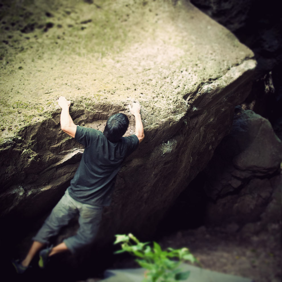
This is the third waterfall. I’ve actually take it a picture of the waterfall before while on Lanipo Trail — the ridge on the other side of the valley. You scramble up the rocks right next to the waterfall for a couple hundreds yards.
Still scrambling here.
More scrambling. You can see a rope is in place (on the right) in case you slip. For the most part, you don’t need it though.
And finally, you get your first glimpse of Ka’au Crater. It looks like a meadow and seems totally out of place.
And now the fun part: hiking the ridgeline. We’re hiking up the summit here with the crater on our left. The trail will take you up to the top, circle around the crater, down a ridge overlooking the valley and then back down to the stream. So, it’s a loop.
Once you get to the summit of the crater ridge you’re rewarded with this amazing view of the Windward side of the island. You can see Olomana, the Mokes, Waimanalo, Chinaman’s Hat, the Sandbar … pretty much everything.
Now find the pink ribbon to the left and continue on the narrow crater ridge.
There are some steep drop offs and the trail is narrow so watch you step. I love this stuff.
But it’s okay to pause every now and then to soak in the view.
Once you get past that section of the ridge you’ll see the trail down.
We’re on the other side of the crater now. I’ve read that the inside of Ka’au Crater is all marsh and that you can’t really walk on it. This would make sense as it’s the source of all the water for the three waterfalls.
As you complete the loop around the crater ridge, look out for the trail that takes you down the ridge. The other option would be to hike back down the three waterfalls and into the valley, but at this point in the hike, that option would be a bit too exhausting.
The ridge takes you almost back to the starting point of the hike. Cross that stream a couple of times and you’re out of the forest.
Time to take our shaky legs home.
See also:
- Ka’au Crater Hike on a map
- Justin’s video recap of the Ka’au Crater hike on Vimeo
- The ridge directly to the east is Lanipo. You can hike Lanipo and connect it to Ka’au Crater.


Dan Zelikman says,
Chat, awesome hike! Awesome shots! Awesome, awesome, awesome.
DavidChat says,
Dude, thanks. Yeah man, I was still bummed out about Pu’u Kalena being closed during the first part of the hike. But this trail turned out to be pretty great. Super fun hike.
chris walker says,
Some of the best shots I’ve seen of this and other trails! I write hiking articles for the web and I was hoping I could use some of your photos for tehm. I would give you credit of course. My articles are here:
http://www.examiner.com/hiking-in-honolulu/christopher-walker
DavidChat says,
Hi Chris…thanks! I’ll email you.
Craig Kim says,
Awesome pics as usual, going to have to finish this hike one of these days. Did you guys walk up the private road?
DavidChat says,
Thanks dude! I think we walked up the private road. I think there’s only one road that leads up to the gate.
Rico says,
Hey, so i was wondering how do you get to the fence? Do you keep walking waiomao to get there or is the another way?
Thanks brah.
DavidChat says,
Hi Rico…yep pretty much. Just park near the Zen Center towards the end of Waiomao and keep walking up the road until you hit the gate. Can’t miss it.
pollywakit says,
Hey David! we just did this hike on saturday.. INTENSE! it was pouring down raining, just made it all the more interesting (and VERY muddy, with the waterfalls over loaded with water)! But we LOVED it!
I just have one question.. we ended up taking a different path than what you guys did and i’m not sure how.. when we got to our “peak” you could only see half the crater, it continued, but we definitely did something different, because my views were not as high up as yours..
Theres a part in the path where it goes to a fork at the stream.. we took the left trail which was marked by pink flags.. where as the right trail was marked by yellow..
i was just wondering if the right side will take you all the way around the crater, or if theres a different path for that we might have missed? ours took us a very very short way around the crater and immediately started to go down a trail through a wooded area, and brought us out the same place yours does.
i’m just not sure what path we missed that takes you completely around the crater?
from the path we were on the pole line you guys are walking next to, was directly across from us and we could see the trail that went all the way up, just had no idea where we went wrong that we didnt get to it.
Thank you so much!
DavidChat says,
Hmm…so you went up the three waterfalls right? It sounds like after you got to the top of the third waterfall you went left and ended up on the trail that takes you back down. I’m thinking that’s the trail we used to get down after we circled the crater. I haven’t done this hike in a while so I’m not sure how the ribbons are currently set up. But, at the top of the third waterfall you want to head towards the right and uphill. You should eventually see this faint trail.
But, the trail up to the crater would turn into mud in heavy rain so it might be good that you skipped it. And since it was raining you probably wouldn’t have seen the view of the Windward side anyway. It would definitely be worth doing again though on a clear day. If you want to mix it up, try doing Lanipo and connecting it to Ka’au Crater. My buddy Troy did it recently (check his blog post here).
Btw, did you happen to see rock climbers at the very beginning of your hike? I was there with some guys from the rock gym climbing the boulders. We said “Hi” to a bunch of hikers. Maybe one of them was you!
pollywakit says,
yep, we went up the waterfalls and went left.. that must have been where we went wrong then. The trail we took went up the ridgeline just a little bit, before it started going back down. so i know exactly where your talking about for next time, we’re definitely taking the high road next time we do it! The trail was terribly muddy, we were slipping all over the place, so your right, it probably wouldnt have been a good idea to go the high road that day. SO MUCH RAIN!! we were completely soaked.
I loved climbing up the waterfalls though, it was so much fun. some places definitely need ropes replaced though.. the ledge we had to shuffle across had a rope about as thick as a shoe lace to hold on to. haha but we didnt have much of a problem with it. the rope more so gave us something to do with our hands while we were making it across.
We did see some rock climbers!! We actually saw their car parked in the parking lot when we started too, it had the rock gym stickers on the back window!! its a very good chance we ran into you guys!!
CnK says,
Great music and photos. Thanks for the tips. I can’t wait to do this hike.
DavidChat says,
Thanks CnK :) have a great time on the trail.
Brandon says,
hey man, i was just wondering what is the difficulty of this hike and is it well marked so that were not off trail? Thanks bro!
DavidChat says,
hi brandon … i think most people would consider this an intermediate level hike. it’s marked okay. the path is very well defined so it would be hard to go off trail. the only part that’s a little confusing is all the stream crossings at the beginning. you just need to keep an eye out for pink ribbons on the other side of the stream to see where to cross. but as long as you keep hitting the waterfalls you’re all good.
Meg Hargis says,
Badass pictures. I just did that hike a few hours ago, and I’m pretty pleased with myself.
DavidChat says,
:)
jake says,
david, your site is awesome.
attempted this hike today with my wife and the entrance to the hike is guarded by a mangy dog with messed up eyes. he is rather unfriendly and not super violent, but getting around him is nontrivial and he barks a lot. i am guessing the inhabitant(s) of this road are none too fond of hikers walking past/on their property. the dog lunged at me as i was walking away from him but fortunately his depth perception is messed up and did not land a successful bite.
as a workaround we went up the ridge immediately east of the valley but my wife is not nearly as excited by backcountry hiking as i am. we descended back down from the ridgeline after getting up there, it was an 800 ft altitude gain. taking the ridgeline a couple miles north seems to provide an alternate route to the peak you mention. the trail here is very slow going and not maintained.
having been thwarted by the dog my suggestion is to bring either (a) a decent supply of dog treats or food dogs like or (b) some form of tranquilizer for the dog. (a) is probably easier ;). such a shame that the residents have a dog blocking the entrance to the hike.
DavidChat says,
hi jake, thx for dropping the comment! i’ve heard about this dog but never seen him myself. thanks for the heads up!